Day 1 - Kırıkkale
21 July 2023
Journal Notes
General
Kırıkkale is the capital of Kırıkkale Province in the Central Anatolia Region of Turkey, in the Middle Kızılırmak section of the Anatolian interior. The city lies about 80 kilometres east of Ankara on the Ankara-Kayseri railway and on the main roads that link the capital with eastern Anatolia, the Black Sea region and the south-east. Provincial territory covers 4,791 square kilometres on both banks of the Kızılırmak, the Halys of antiquity and the longest river that flows entirely within Turkey. The province is divided into nine districts around its capital; the city of Kırıkkale had 186,960 inhabitants in 2022 and the province about 277,000, roughly nine tenths of them living in towns, an unusually urban profile for inland Anatolia that reflects the province’s industrial history.
Kırıkkale is above all a child of the Turkish Republic. Before the 1920s the site was an insignificant village on the steppe; the decision to build the country’s principal state arsenal near Ankara turned it within two decades into a factory town of industrial quarters and planned housing, and later into one of the foremost industrial centres of inland Turkey. Defence manufacturing still shapes the local economy, organised around the factories of MKE, the Mechanical and Chemical Industry Corporation: small-arms, ammunition, brass, explosives and heavy-weapons works with a steel foundry. Alongside them stand the steel and machinery plants that expanded in the 1950s and 1960s and the large Tüpraş oil refinery, the Central Anatolia Refinery, opened in 1986. Public administration and education complete the picture; Kırıkkale University, founded in 1992, has given the city a second role as a regional centre of higher education and research, and the provincial capital functions as the commercial and service hub for the surrounding districts.
The setting is the high steppe of central Anatolia. Summers are hot and dry, winters cold and snowy, and rain falls mainly in spring and autumn; with some 370 millimetres a year the climate is classed as cold semi-arid (Köppen BSk). The natural vegetation is steppe and scrub, while the floodplain of the Kızılırmak and its irrigated strips support orchards, vegetable gardens and, in places, rice. Wheat, barley and sugar beet are the staple field crops, and viticulture matters: the province ranks among the leading vine-growing provinces of Turkey, its vineyards spreading across the rolling country south and east of the city.
For the traveller heading east, Kırıkkale is first of all a gateway: a natural overnight stop where the modern Turkish townscape of apartment blocks, boulevards and shopping streets stands within sight of the great factory walls and the wide brown river. Its attractions are modest and honest, rooted in Republican industrial heritage and in the Kızılırmak valley, and the city makes a quietly revealing introduction to inland Anatolia before the older landscapes of the region begin.
History
The region around Kırıkkale has been settled since antiquity, and archaeological sites in the province attest occupation in Hittite, Phrygian, Roman and Byzantine times, though none of those periods left monuments within the modern city itself. Ancient writers recorded a settlement called Sarmalius somewhere in the area, but its exact position is unknown. For most of antiquity the great river mattered more than any town. The Hittites called it the Maraššantiya, and it marked the western boundary of their homeland of Hatti; the Greeks knew it as the Halys. As late as the sixth century BC the Halys formed the frontier between the kingdom of Lydia and the Median and Persian empires, and the battle of the eclipse, fought beside the river on 28 May 585 BC, ended the war between Lydia and Media. In 547 BC the Lydian king Croesus crossed the Halys to attack the Persians and was defeated, after which the river lost its role as a political border; under the Romans it became an interior river, later still the dividing line between the kingdoms of Pontus and Cappadocia.
The name Kırıkkale belongs to a much later layer. It combines kırık (‘broken’) with kale (‘castle’), and is usually explained through two local place names: Kırık, a village about three kilometres north of the present centre, and Kaletepe, a fortified hill within the urban area; older records write the name as Kırık Kal’a. The old village, which survives in name in the modern Kırıkköyü quarter with its mosque and cemetery, was a hamlet of barely a dozen households when the Republic launched its great programme of industrialisation. Kırıkkale then belonged to the district of Keskin in Ankara Province. What transformed it was the railway. The state line from Ankara towards Kayseri was laid through the steppe here, and in 1925 the government chose the spot, close to the capital yet far from the coast and from easy attack, for the foundations of its artillery and ammunition works.
Through the early 1930s the first factory quarters grew up along the railway, in the neighbourhoods today called Fabrikalar, Ovacık, Kurtuluş and Hüseyin Kahya, and in 1929 the settlement was constituted a sub-district (bucak) under the name Kırıkkale. Its population, about 3,000 in 1929, reached 4,599 by the census of 1935. The arsenal then developed into an integrated complex: shell and cartridge works, brass and steel foundries, a small-arms factory whose Mauser-pattern rifle of 1938 and its copies of the Walther PP pistol were stamped with the city’s name and are still known to collectors simply as ‘Kırıkkale’, and finally gun and powder works towards the end of the decade. Workers arrived from all over central Anatolia; the settlement became a municipality in 1941, and the factory town, laid out around its industrial core with planned residential quarters, grew steadily through the Second World War and after it.
In 1950 the military factories were reorganised under the newly founded MKE corporation, and in the 1950s the city’s steel works expanded to become among the largest in Turkey, specialising in high-quality alloy steel and machinery; chemical plants followed in the 1960s, and the Tüpraş refinery, opened in 1986, added a petrochemical dimension to the town. Administratively Kırıkkale had long outgrown its role as a district of Ankara: on 21 June 1989 the province of Kırıkkale was created from part of Ankara Province at a ceremony led by President Turgut Özal, with the city as its capital, and Kırıkkale University followed in 1992. Since then the industrial economy has matured, services and education have grown in importance, and the population has fluctuated around 190,000 since 2009 rather than rising as it once did. Nearly a century of industry has left the city with a distinct identity, still bound to its founding purpose as the arsenal town of the Republic.
Geology
Kırıkkale lies on the Central Anatolian Plateau, the high interior of Asia Minor made of Neogene basins, volcanic fields and older eroded massifs. The city itself stands low, at about 710 metres above sea level, where the Kızılırmak has cut its valley into the plateau, while much of the surrounding province rises between about 1,100 and 1,200 metres. The two principal lowlands, the Kırıkkale Plain and the Kızılırmak Plain, are structural depressions aligned roughly north-east to south-west and linked by a narrow tectonic trough. They formed by subsidence along faults and were then filled, first by pyroclastic material carried from neighbouring volcanic areas, later by thick alluvial fans and floodplain deposits brought down from the bordering highlands. Since the Pleistocene the rivers have dissected these soft fills, cutting terraces and leaving plateau surfaces along the valley margins; broad alluvial fans and debris cones still spread out where side streams reach the plains. Between the basins rise rounded, deeply weathered massifs; west of the city Küre Dağı reaches 1,555 metres and carries the province’s finest oak forest.
The dominant natural feature is the Kızılırmak, the ‘red river’, historically the Halys. With a course of 1,355 kilometres it is the longest river flowing entirely within Turkey. It rises near İmranlı in Sivas Province, flows west and south-west across the plateau, then sweeps through a vast arc, the Halys bend, around the salt lake of Tuz Gölü before turning north towards the Black Sea, which it reaches at Bafra in Samsun Province. A 94-kilometre reach crosses Kırıkkale Province, passing south and west of the city, and along this stretch the river has built a broad floodplain whose waters irrigate orchards, vegetable gardens and rice paddies. The Kızılırmak is not navigable; its energy is harnessed by a chain of dams, among them Kapulukaya, completed within the province in 1979, whose plant generates 54 megawatts. The province has no natural lakes, only the reservoirs held back by such dams. In the north-east the river’s major tributary, the Delice, known to the ancients as the Cappadox, follows the borderlands between the district of Delice and the province of Çorum before joining the Kızılırmak.
The basin-and-plain pattern of the province is young, the product of the neotectonic regime that has shaped Anatolia since the Late Miocene. Turkey rides on the Anatolian plate, a continental block bounded by the North Anatolian and East Anatolian transform faults and displaced westwards relative to Eurasia as the Arabian plate collides with it from the south-east. Kırıkkale lies well inside this block, where the strain of that collision is taken up by many smaller faults and by the slow subsidence of basins rather than along a single master fault, and the tectonic depressions around the city record this internal deformation. The plateau may look still, but the landscape is alive: the same faults that created the plains continue to move, feeding the Kızılırmak with sediment and slowly remodelling the valley floors that agriculture now occupies.
Things to See
Kırıkkale is not a city of famous monuments; its interest lies in the story of the Republic’s industry and in the river valley around it, and its sights can be seen comfortably on an overnight stop.
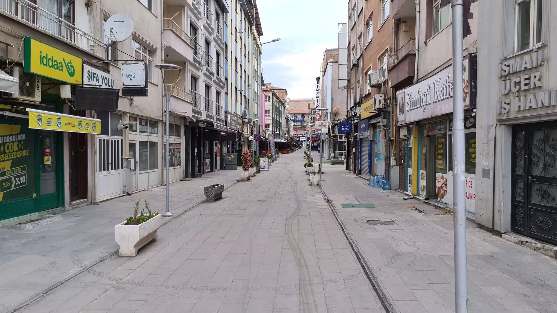
The city centre is a grid of broad boulevards and apartment-lined shopping streets, almost all of it built from the 1940s onwards. Atatürk Boulevard forms the commercial spine, lined with shops, banks and tea gardens, and the modern clock tower at its heart is the city’s best-known landmark; nearby stands the Nur Mosque, the principal modern mosque of the town. The centre is compact, and its pedestrian streets, filled with the everyday commerce of a provincial capital, give the quickest impression of Kırıkkale life.
MKE Weapons Industry Museum (Silah Sanayi Müzesi) is the most distinctive sight of the industrial city, housed in the grounds of the MKE weapons factory on the road to Yahşihan. Recognised in 1987 as the first private museum of Kırıkkale, it was founded on 15 July 1990 and reopened in its present halls in 1993 after renovation. The collection brings together roughly 500 pieces spanning the 13th and 14th centuries to the 20th: edged weapons, armour and firearms of Turkish and European make, gathered after the War of Independence from private owners in Istanbul and the Black Sea region, from the old Tophane arsenal and from the military factories. A 14th-century mail shirt and helmet count among the highlights. Because the museum belongs to the factory, it is open free to the public during Museums Week (18 to 24 May) and at other times by prior arrangement with MKE.
The MKE factory district occupies the west of the city behind long perimeter walls, a landscape of workshops, foundries and chimneys whose beginnings reach back to the foundations laid in 1925. Around the plant, the Fabrikalar quarter, the oldest part of the modern town, grew along the railway with its grid of streets and plain utilitarian housing; it still conveys the character of the early Republican company town better than any other part of Kırıkkale, though the works themselves are naturally closed to visitors.
Kırıkköyü quarter, north of the centre, preserves the traces of the old village of Kırık from which the city takes its name. The small Kırık Köyü Mosque and the old cemetery stand among the modern houses, and this quarter is the one place in town where something of the pre-industrial settlement can still be sensed.
The Kızılırmak corridor gives the city its most open spaces. Riverside parks and promenades line the river where it skirts the south and west of the town, and the corridor is listed among Kırıkkale’s notable landmarks; in the evening the water moves broad and brown between its cultivated flats while the town rises behind it on the plateau edge. For all its industrial setting, the riverbank is the natural lung of the city.
Kapulukaya Dam impounds the Kızılırmak downstream of the city. Completed in 1979 by the State Hydraulic Works as an embankment dam with a hydroelectric plant of 54 megawatts, it holds back one of the largest sheets of water in a province that otherwise has no natural lakes; its long reservoir reaches back along the valley between steppe-covered hills and is the most expansive piece of open landscape near the town.
Çeşnigir Bridge, the finest monument of the province, lies some way to the south-west, where it carries a walkway across the Kızılırmak between the town of Karakeçili and the village of Köprüköy. The bridge is a work of the Seljuk Sultanate of Rum, dated on architectural grounds to the 13th century. It is built of dressed stone with nine main arches and three smaller arches that lighten the abutments, and it is counted a noted example of Seljuk architecture. Tradition relates that the army of Timur crossed it on the march to the Battle of Ankara in 1402, and later repairs are attributed to the Ottoman court architect Sinan in preparation for Sultan Selim I’s Egyptian campaign. After the waters of the Kapulukaya reservoir rose behind the dam, the bridge was closed to vehicles in 1989; it has since served pedestrians and was restored in 2010.
References
- Lewis, Bernard (1961). The Emergence of Modern Turkey. London: Oxford University Press.
- Zürcher, Erik J. (2004). Turkey: A Modern History. London: I.B. Tauris.
- Bozkurt, Erdin; Winchester, John A. and Piper, John D. A. (eds) (2000). Tectonics and Magmatism in Turkey and the Surrounding Area. Geological Society Special Publication 173. London: Geological Society.
- Ayliffe, Rosie; Dubin, Marc; Gawthrop, John and Richardson, Terry (2003). The Rough Guide to Turkey. London: Rough Guides.
- Kırıkkale Belediyesi (Municipality of Kırıkkale). www.kirikkale.bel.tr/
- Makina ve Kimya Endüstrisi Kurumu (official site of MKE). www.mke.gov.tr/
- Kırıkkale. en.wikipedia.org/wiki/Kırıkkale
- Kırıkkale Province. en.wikipedia.org/wiki/Kırıkkale_Province
- Kızılırmak River. en.wikipedia.org/wiki/Kızılırmak_River
- Mechanical and Chemical Industry Corporation. en.wikipedia.org/wiki/Mechanical_and_Chemical_Industry_Corporation
- Çeşnigir Bridge. en.wikipedia.org/wiki/Çeşnigir_Bridge
- Kapulukaya Dam. en.wikipedia.org/wiki/Kapulukaya_Dam
- Anatolian plate. en.wikipedia.org/wiki/Anatolian_plate
- Kırıkkale (il), Turkish Wikipedia. tr.wikipedia.org/wiki/Kırıkkale_(il)
- Kırıkkale, Turkish Wikipedia. tr.wikipedia.org/wiki/Kırıkkale
- MKE Silahsan Müzesi, Turkish Wikipedia. tr.wikipedia.org/wiki/MKE_Silahsan_Müzesi