Day 9 - Coral Bay / Ningaloo Reef





Journal Notes
General
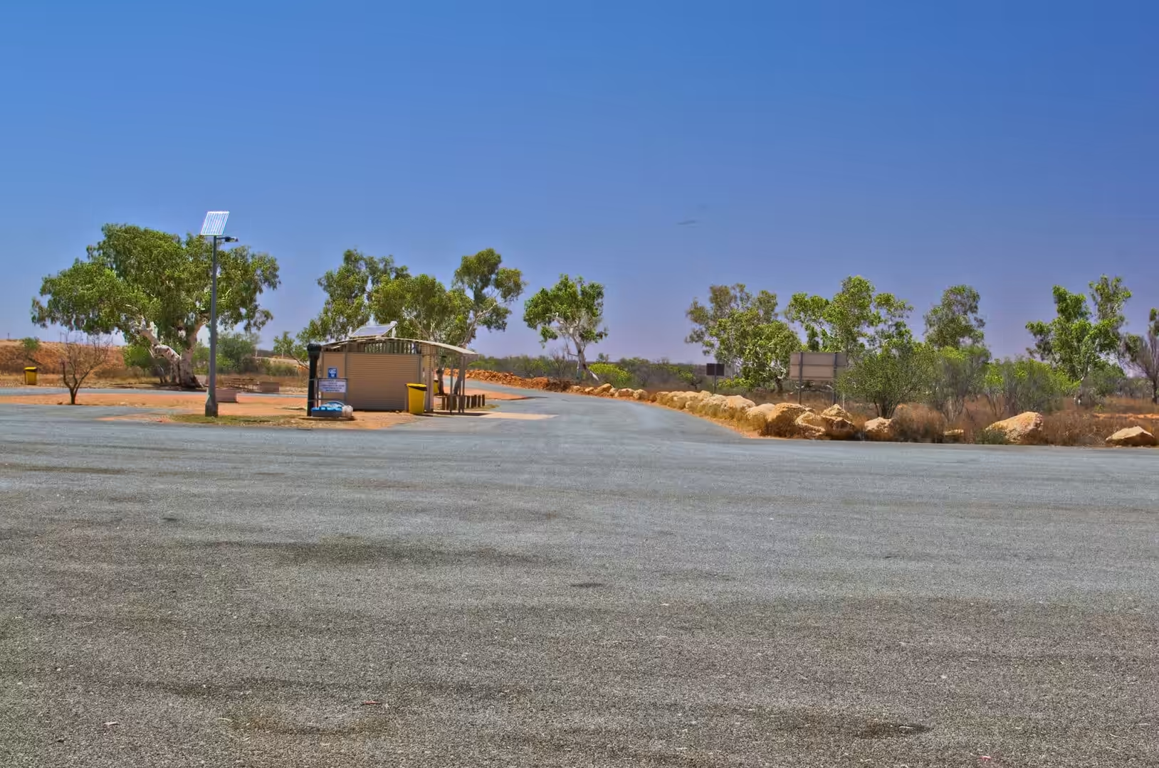
The ninth day was the longest drive of the journey so far: from Carnarvon north across the Tropic of Capricorn to the little settlement of Coral Bay, a distance of around four hundred kilometres through country with almost nothing in it. The first stop was a rest area under eucalyptus trees with a concrete table and a shelter, the second was a roadhouse, and somewhere between them a road train with three trailers came past in the opposite direction and shook the car as it went by.
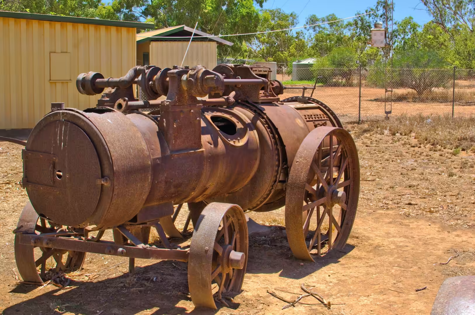
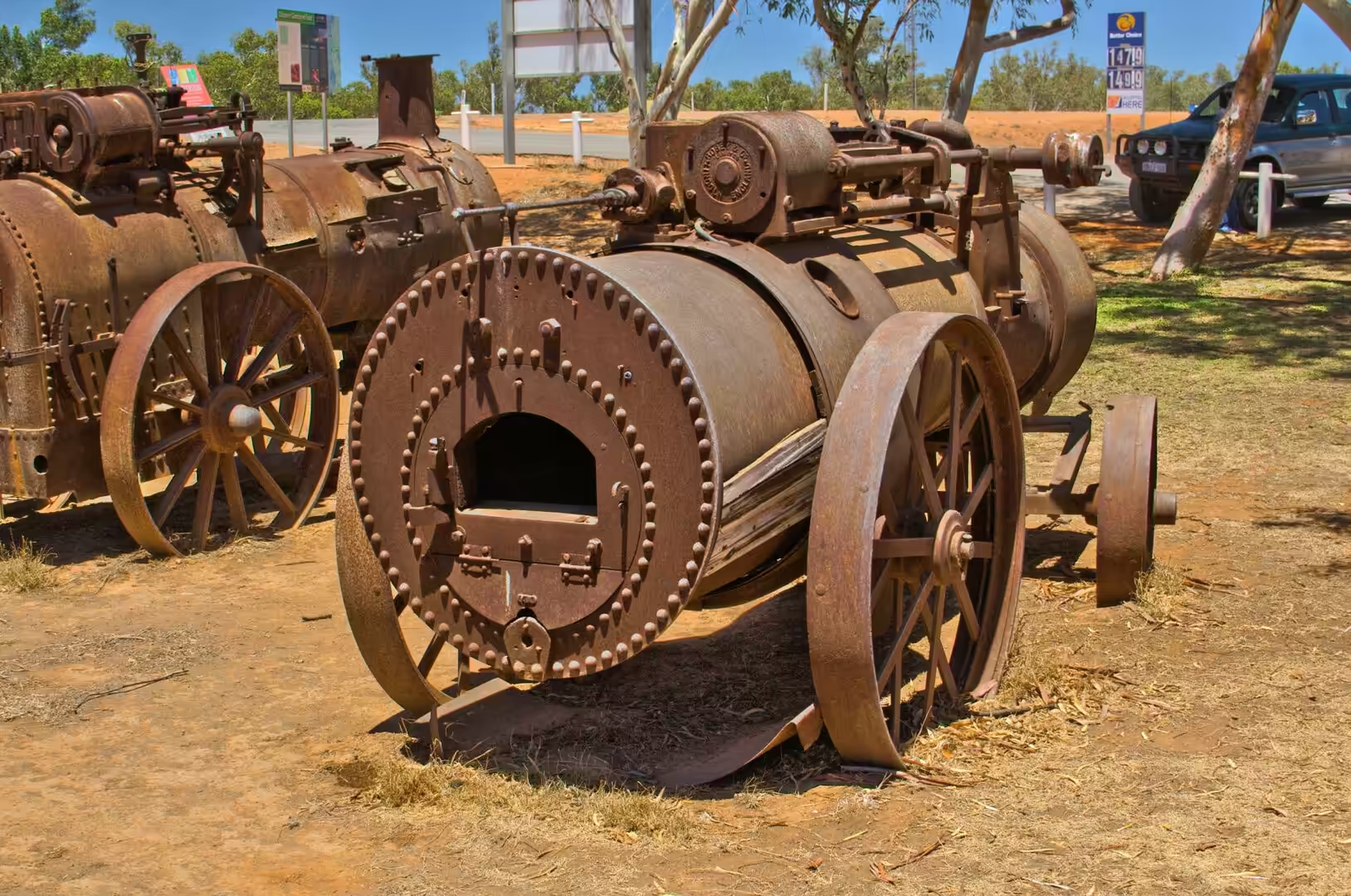
The oddities of the roadside kept the day interesting. A yard beside the highway holds a collection of rusted steam engines and boilers on iron spoked wheels, arranged in the dirt beside a corrugated iron shed and a green vintage motor car, and the collection is worth a stop for anyone interested in machines. A brown sign marks the Tropic of Capricorn, which is roughly where the sun stands overhead at midday in December, and the country either side of it is dry spinifex grassland with termite mounds standing up out of it like small towers.
By late afternoon the road reached the coast and turned north along the shore, and the water that appeared beside it was the reef: shallow, pale, turquoise, and marked by the darker patches of coral and seagrass that give the Ningaloo coast its colour. Coral Bay itself is a small settlement of houses, a caravan park, a shop and a few dive operators on a bay that opens directly onto the reef. The camp was pitched a few hundred metres from the beach, and the evening was spent watching the sun go down into water that was still warm at eight o’clock.
Long drives in the outback have their own rhythm, and the ninth day had settled into it. Fuel is bought at every opportunity whether the tank needs it or not, the water bottles are refilled at every tap, and the passenger keeps a lookout for kangaroos on the verge in the last hour of light. The radio alternates between stations that fade in and out and a playlist that has been heard too many times, and the conversation covers the kind of ground that only long drives allow. Arriving at the coast in the evening, with the reef showing as a band of turquoise beside the road and the tent going up in the last of the light, is the reward that the day was built around.
History
The Tropic of Capricorn is the line of latitude at which the sun is directly overhead at midday on the December solstice, and it crosses the Western Australian coast at this latitude, twenty three and a half degrees south of the equator. Everything north of the line has the sun at its zenith twice a year; everything south of it, as here, has it overhead once, in the southern summer. The sign beside the highway is a marker for travellers rather than a physical boundary, but the change in the country either side of it is real enough: the summer becomes hotter, the rain more erratic and the vegetation more sparse.
The road that crosses it is part of the North West Coastal Highway, the route that connects the settled south west of the state with the north. It was built for freight as much as for tourism, and the road trains that use it are the visible sign of that: long combinations of trailers carrying fuel, machinery and supplies to the mines and the stations, and cattle and ore coming back. Driving on the highway means being overtaken by them, being passed by them and waiting behind them, and the etiquette of the road is built around giving them the space and the warning they need.
Coral Bay is a young settlement by the standards of the coast. It grew out of a fishing and camping site on the shore of a sheltered bay and became a holiday destination because the reef comes within swimming distance of the sand, which is rare for a barrier reef system, and because the bay is protected enough for boats to be launched and for children to swim. There is no town as such: a shop, a caravan park, a handful of houses and the dive and tour operators who work the reef make up the whole of it, and everything else arrives by road from Carnarvon or Exmouth.
The stations and the mines of the interior are the reason the highway exists, and their history is the history of the region between the wars. Wool from the Gascoyne and the Murchison was carted to the coast at Carnarvon and shipped out from the jetty, and the pastoral leases that produced it were worked with camels, then horses, then trucks. The mining that came later, for iron, gold and salt, used the same road and the same ports, and the road trains that pass Coral Bay today are the direct descendants of the camel teams and the wool wagons. Driving the route in a modern vehicle with air conditioning and a radio, it is worth remembering that the same journey was made with animals and without a road for a hundred years.
Geology
The termite mounds beside the highway are the most visible geological work of any living creature in Australia. Each mound is built from soil, saliva and excrement, cemented into a structure harder than the ground it stands on, and shaped to manage temperature and gas exchange inside. Some species build mounds with a north south orientation that reduces the heat of the midday sun; others build tall chimneys or broad cathedral shapes. From the car they look like a scatter of pale sculptures across the spinifex, and each one is a small settlement with a queen, a workforce and a ventilation system.
The spinifex grassland around them is a plant community adapted to fire, drought and grazing. The clumps grow in rings, the old growth in the centre dies and is replaced at the edges, and the hummocks of sand that build up beneath them are held in place by the roots. Grass that lives like this stabilises the surface of the desert, and the country between the termites and the spinifex is, in a real sense, the product of both.
North of the Tropic the coast becomes the Ningaloo system. The reef is a barrier that runs for hundreds of kilometres along the shore, separated from the land by a lagoon that is shallow and warm, and the whole structure rests on the edge of the continental shelf where the water deepens quickly to the open ocean. The reef is not a wall of coral in the way that the Great Barrier Reef is: it is a series of reefs, channels and lagoons, close enough to the beach at Coral Bay and Yardie Creek for a swimmer to reach, and it is the combination of accessibility and richness that made the coast a World Heritage site.
The lagoon between the beach and the reef is the reason the water looks the way it does. It is shallow, so light reaches the floor and the pale sand reflects it back; it is sheltered, so the sediment settles and the water stays clear; and it is warm, which is why the coral grows here in the first place. The dark patches visible from the shore are the coral heads, the seagrass and the algae that live on the floor of the lagoon, and the deeper blue beyond them marks the edge of the reef where the swell breaks.
The reef at Coral Bay is the visible end of a system that begins far offshore. The Leeuwin Current, a warm flow of tropical water that runs south along the Western Australian coast, brings larvae and warm water to these shores, and the result is a coral community growing at a latitude where cold water would normally be expected. The current is seasonal and variable, the reef has been through bleaching events that killed parts of it, and its condition is monitored closely because the whole coast depends on it. A swimmer in the lagoon is looking at the southern edge of the tropical ocean, held in place by a current that arrives from a thousand kilometres away.
Things to See
The Tropic of Capricorn sign is a compulsory stop of the kind that costs two minutes and is worth two minutes for the sign itself. The country around it is more interesting than the sign: red earth, spinifex, termite mounds and the long straight road running to a horizon that is not interrupted by a single hill. Anyone travelling this way should stop somewhere along it and walk a hundred metres away from the car, because the silence and the emptiness are the experience, and they do not survive a description well.
The roadside collection of steam engines is a reminder that this country was worked long before it was toured. The machinery was brought here for the stations and the mines and left where it stopped working, and the accumulation of rusted boilers, wheels and frames beside a shed has become a small private museum without walls. Similar yards exist beside roads all over the interior, and they are the closest thing the outback has to industrial archaeology.
Coral Bay itself is small enough to walk around in half an hour, and the water is the reason to be there. The bay is sheltered, the beach is white and shallow, and the reef begins a short swim from the sand: a mask and snorkel are enough to see fish, coral, turtles and, in the right season, the whale sharks and manta rays that the coast is famous for. Boat operators run trips out to the outer reef, and the glass bottomed boats that operate in the bay are a good option for anyone who does not want to get wet.
The practical arrangements of the place are simple and should be planned in advance. There is one shop, one caravan park and a limited number of houses and chalets, and in the season they are full: bookings are essential and the nearest alternative accommodation is in Carnarvon or Exmouth, each of them a long drive away. Fuel is available, water is not to be wasted, and the nearest hospital is in Carnarvon. The reward for putting up with all of that is a week of swimming in water that is warm, clear and full of life, with the reef a few metres from the tent.
The roadhouses along the highway are worth a stop, if only for the reminder of what they do. They are fuel station, shop, post office, cafe and meeting place in one building, they are spaced at the distance a vehicle can travel on a full tank, and the noticeboards inside carry the news of the district: lost dogs, shearers wanted, fuel prices and the date of the next race meeting. The food is plain and the coffee is instant, and the people behind the counter know exactly how far it is to the next fuel and exactly what the road is like beyond it. Ask them about the weather and they will give an honest answer.
References
- Wikipedia contributors (2026). Coral Bay, Western Australia. en.wikipedia.org/wiki/Coral%20Bay%2C%20Western%20Australia
- Wikipedia contributors (2026). Ningaloo Coast. en.wikipedia.org/wiki/Ningaloo%20Coast
- Wikipedia contributors (2026). Ningaloo Reef. en.wikipedia.org/wiki/Ningaloo%20Reef
- Wikipedia contributors (2026). Ningaloo. en.wikipedia.org/wiki/Ningaloo
- Wikipedia contributors (2026). Ningaloo Marine Park (Commonwealth waters). en.wikipedia.org/wiki/Ningaloo%20Marine%20Park%20%28Commonwealth%20waters%29
- Wikipedia contributors (2026). Cape Range National Park. en.wikipedia.org/wiki/Cape%20Range%20National%20Park
- Wikipedia contributors (2026). Exmouth, Western Australia. en.wikipedia.org/wiki/Exmouth%2C%20Western%20Australia
- Wikipedia contributors (2026). Whale shark. en.wikipedia.org/wiki/Whale%20shark
- Wikipedia contributors (2026). North West Cape. en.wikipedia.org/wiki/North%20West%20Cape
- Wikipedia contributors (2026). Indian Ocean Drive. en.wikipedia.org/wiki/Indian%20Ocean%20Drive
- Wikipedia contributors (2026). Dugong. en.wikipedia.org/wiki/Dugong
- Duffy S., Layton R.A. (2017) Whale sharks, Ningaloo Reef, Western Australia. Social Marketing. 509-524. doi.org/10.4324/9781315648590-30
- Ceh J., Van Keulen M., Bourne D.G. (2010) Coral-associated bacterial communities on Ningaloo Reef, Western Australia. FEMS Microbiology Ecology. 75. 134-144. doi.org/10.1111/j.1574-6941.2010.00986.x
- (ohne Angabe) (2022) Australia, Western Australia, Pilbara Region, Indian Ocean Coast. Journal of Coastal Research. 100. doi.org/10.2112/jcr-si100-flat-044.1