Stage 7 of 14
Day 7 - Giarre
Journal Notes
General
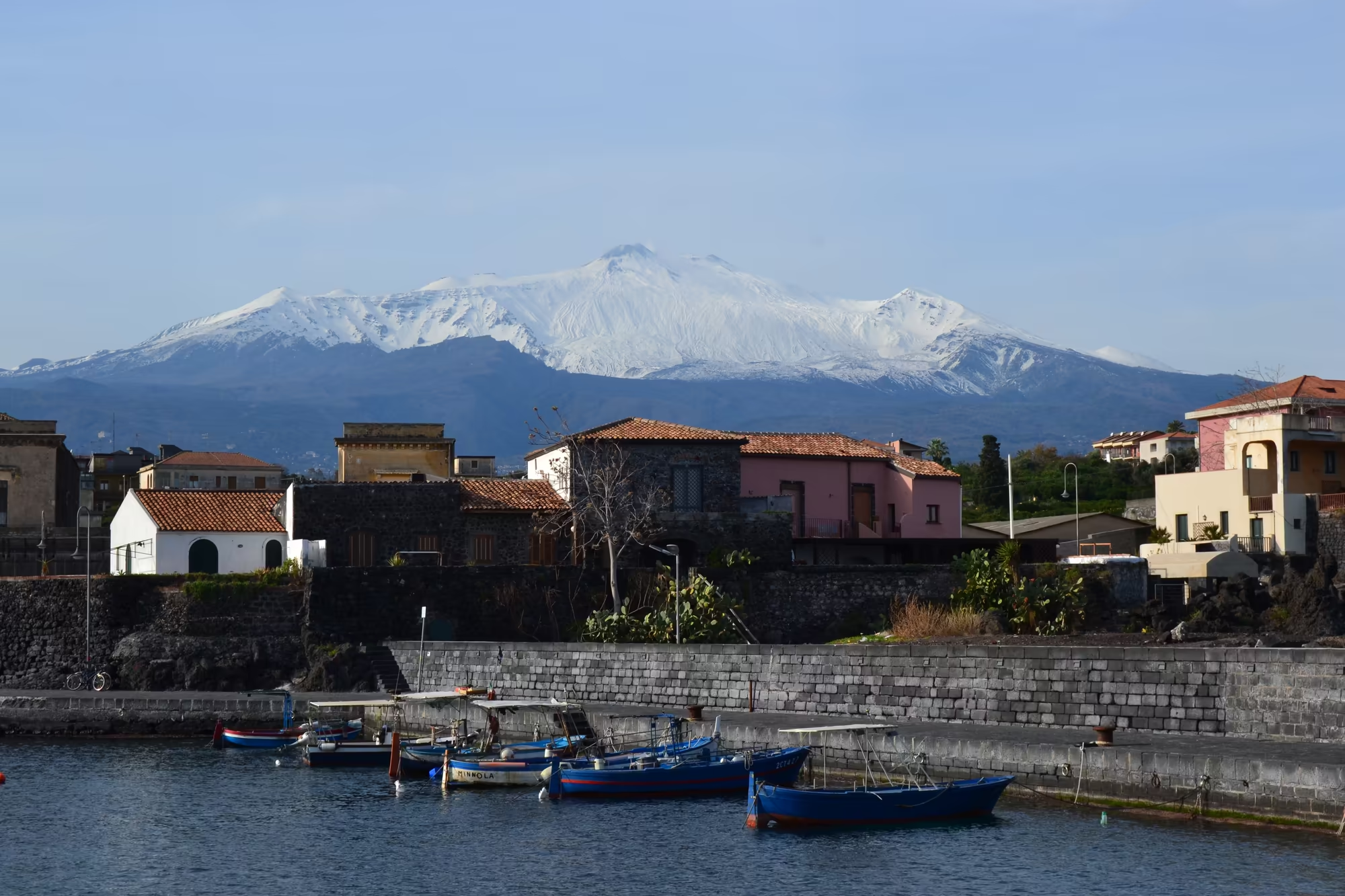
The harbour is the second half of the two towns that share this stretch of coast. Riposto lies next to Giarre and runs down to the sea, and its harbour is the place where the agricultural country behind the towns meets the water: the small fishing boats in this album are moored in a basin protected by a stone quay, with village houses behind them and the snow covered summit of Mount Etna standing above the roofs. The combination is the one that defines the whole coastline, a working harbour at the foot of a volcano.
The position explains the function. Giarre and Riposto form a single built up area between the Ionian Sea and the lower slopes of Etna, and both have lived from the land and from the water for as long as there have been records. The municipality of Giarre is bounded by Acireale, Mascali, Milo, Riposto, Sant’Alfio, Santa Venerina and Zafferana Etnea, so that a short drive inland from the quay crosses several different agricultural belts, from citrus and vegetables at low level to vineyards, olives and chestnut woods higher up the mountain.
In winter the harbour looks the way it should look out of season. The boats lie still in calm water inside the breakwater, the quay is wet, the light is flat and the summit of the mountain is white; a few people work on the boats or walk along the front, and the sea beyond the harbour wall is grey rather than blue. There is none of the busy summer traffic, and the harbour is legible as an instrument rather than as a backdrop, with moorings, ropes, buoys and a slipway all in plain view.
The town behind the boats is the other half of the picture, and it is worth walking as well as looking at from the water. Streets of shuttered houses run back from the front, the cathedral of Giarre and its piazza stand a short distance inland, and the villages of the mountain are within a twenty minute drive. For a traveller using the coast as a base, this is the arrangement of the day: the harbour in the morning, the town at midday and the slopes of the volcano in the afternoon, all within a few kilometres of one another.
The harbour works for more than the village itself. Riposto handles the produce of the surrounding country as well as its own catch, and the boats that lie in the basin in winter belong to families whose income comes from the land as much as from the sea; a good part of the citrus, wine and vegetables grown between Giarre and the mountain has left the island through this harbour for two hundred years. In a place where the coastline is steep and rocky, a protected basin is worth as much as a road.
History
The two towns have been one administrative unit and two municipalities by turns, and the harbour is where that history is easiest to see. During the fascist era Giarre was joined to Riposto under the single name of Jonia, and the two were separated again in 1945; a shared waterfront with two town councils behind it is the result. Before that, from the late sixteenth century until 1815, Giarre was a village of the county of Mascali, and the coast here belonged to the agricultural economy of that estate, with the sea used for fishing and for moving produce.
Fishing and farming were never separate occupations in a place like this. The boats worked the Ionian Sea for the species that are caught close to shore, the land produced citrus, olives and vegetables which needed to be moved to market, and the harbour served both. The small boats moored inside the breakwater in the pictures are the direct descendants of that system, and the fact that they are owned by families rather than companies is part of the same long continuity.
The far side of the coast has its own history, which is visible from the quay on a clear day. To the north the mountains of the Peloritani run down towards the Strait of Messina, and the crossing of that strait has been the gateway to Sicily for every power that has held the island: Greek cities, Roman province, Arab emirate, Norman kingdom, Spanish monarchy and finally the Kingdom of the Two Sicilies, which was unified with the rest of Italy in 1860 after the expedition led by Giuseppe Garibaldi and the plebiscite that followed.
The town of Giarre itself was also the site of the Giarre murder in 1980, an event that entered the national discussion of crime and civil society in Sicily in those years, and which the town has since had to carry as part of its public story. Walking past the ordinary streets between the harbour and the piazza, there is nothing to mark it, and that is precisely how most places live with difficult histories: the town continues, and the events are remembered in other ways.
The harbour’s independence ended and began more than once, which is why the two towns share it. The county of Mascali, of which Giarre was a village from the late sixteenth century until 1815, organised the coast as an agricultural estate, and Riposto developed in the same period as its port; the merger of the two towns as Jonia during the fascist era and their separation in 1945 left the water and the quay in the middle of a boundary that runs along the streets behind it. The boats, the sheds and the ice plant have outlasted all of those arrangements.
Geology
The harbour sits on volcanic ground. The coast of this part of eastern Sicily has been built and rebuilt by lava reaching the sea, so the shoreline is a mixture of rocky platforms, black pebble beaches and low cliffs of solidified flow, and the breakwaters of the ports follow the same material. Mount Etna has produced at least 60 flank eruptions since the year 1600, nearly half of them since the beginning of the twentieth century, and some of those flows reached the coast north and south of here; the villages of Santa Tecla and Stazzo, north of Acireale, are built on the broad delta that one such flow made when it entered the sea around 1030 CE.
The same geology makes the sea floor irregular. Where lava entered the water the bottom is rock rather than sand, and the catches and the fishing grounds of the local boats follow those features; the turquoise colour of the shallower water in the pictures comes from light on a rocky rather than a sandy bottom. Inland, the lava weathers into a fertile soil, and the agricultural belt between the coast and the mountain is worked on ground whose age can be read from the terraces and the vegetation.
The mountain also decides the weather. Because it stands above the coast, the summit condenses cloud and receives snow in winter while the coast below remains mild, and the difference between the two is one of the reasons this stretch of Sicily is farmed so intensively: cold air drains down the slopes at night, the sea moderates the days, and the result is a long growing season with enough winter chill for citrus to sweeten on the tree, which is why the fruit is still hanging in February.
For anyone looking at the harbour, the useful thing to understand is that the landscape is young. The shoreline as it appears now is a recent arrangement of flows, and the channels, walls and roads along the coast are as much a response to the mountain as the harbour walls are a response to the sea. The whole arrangement, a breakwater, a quay, a town and an orange grove, is built on a slope of lava between a sea that is calm out of season and a volcano that is not.
The same lava that built the coast has shaped the harbour. Where flows reached the sea they built platforms and deltas of hard rock, and the breakwater here stands on and beside that material; the depth of the basin and the lie of the seabed are both consequences of how the flows arrived, one on top of another, over the last few thousand years. Where the lava came down in 1030 CE, north of Acireale, the delta it made now carries the villages of Santa Tecla and Stazzo, which is the same story at a later date.
Things to See
The first thing to look at is the mooring line, because everything else depends on it. Small fishing boats lie in the calm water of the basin, tied to the quay or to each other, with the stone wall of the breakwater behind them and the houses of the village climbing the slope; the mountain with its snow covered summit stands above the roofs in the middle distance. In February the harbour is quiet, and the boats, the ropes and the neat row of hulls carry the whole picture.
The quay itself is worth a slow walk. The surface is rough stone, the bollards are worn, and the fishing gear is stacked where it is used rather than displayed, so that the harbour reads as a place of work. Gulls stand on the breakwater, and the water inside the harbour is dark and still while the sea outside it is moving; from the end of the wall the view takes in the coast to the north, the mountains behind the Strait of Messina and the whole eastern flank of the volcano.
Behind the harbour the town continues. The streets between the waterfront and the centre are narrow and shuttered, with balconies, potted plants and small shops, and the neo classical cathedral of Giarre, begun in 1794 and dedicated to Saint Isidore, faces its piazza a short walk inland with the Oratory of Saint Philip Neri nearby. Coming from the harbour, the change from boats to a baroque square takes about ten minutes on foot and passes through the middle of ordinary town life.
The last part of the day belongs to the mountain again. Driving up through the agricultural belt from the coast, the groves give way to terraces, then to olives and vines, and finally to the dark upper slopes where the snow begins; the summit stays in view for most of the climb, and from the higher villages the whole coast, the harbour and the two towns can be seen at once. It is the view that makes sense of the place: a shore of lava, a harbour, a belt of gardens and a white cone above all of it.
The boats themselves are worth looking at closely. Most are small, painted in bright colours and worked by two or three people, with the gear stowed where it is used and names painted on the hull; some have been converted to other work, and a few are laid up on land. The row of hulls along the quay, with the mountain behind them and the water moving in the basin, is one of the most complete pictures of the coast: a harbour, a town and a volcano in a single line of sight.
References
- Behncke, B., Neri, M. & Nagay, A. (2005). Lava flow hazard at Mount Etna (Italy): new data from a GIS-based study. Kinematics and Dynamics of Lava Flows, Geological Society of America. doi.org/10.1130/0-8137-2396-5.189
- Wikipedia contributors (2026). Expedition of the Thousand. en.wikipedia.org/wiki/Expedition_of_the_Thousand
- Wikipedia contributors (2026). Giarre. en.wikipedia.org/wiki/Giarre
- Wikipedia contributors (2026). Giuseppe Garibaldi. en.wikipedia.org/wiki/Giuseppe_Garibaldi
- Wikipedia contributors (2026). History of Sicily. en.wikipedia.org/wiki/History_of_Sicily
- Wikipedia contributors (2026). Ionian Sea. en.wikipedia.org/wiki/Ionian_Sea
- Wikipedia contributors (2026). Kingdom of the Two Sicilies. en.wikipedia.org/wiki/Kingdom_of_the_Two_Sicilies
- Wikipedia contributors (2026). Mascali. en.wikipedia.org/wiki/Mascali
- Wikipedia contributors (2026). Messina. en.wikipedia.org/wiki/Messina
- Wikipedia contributors (2026). Mount Etna. en.wikipedia.org/wiki/Mount_Etna
- Wikipedia contributors (2026). Riposto. en.wikipedia.org/wiki/Riposto
- Wikipedia contributors (2026). Sicily. en.wikipedia.org/wiki/Sicily
- Wikipedia contributors (2026). Strait of Messina. en.wikipedia.org/wiki/Strait_of_Messina