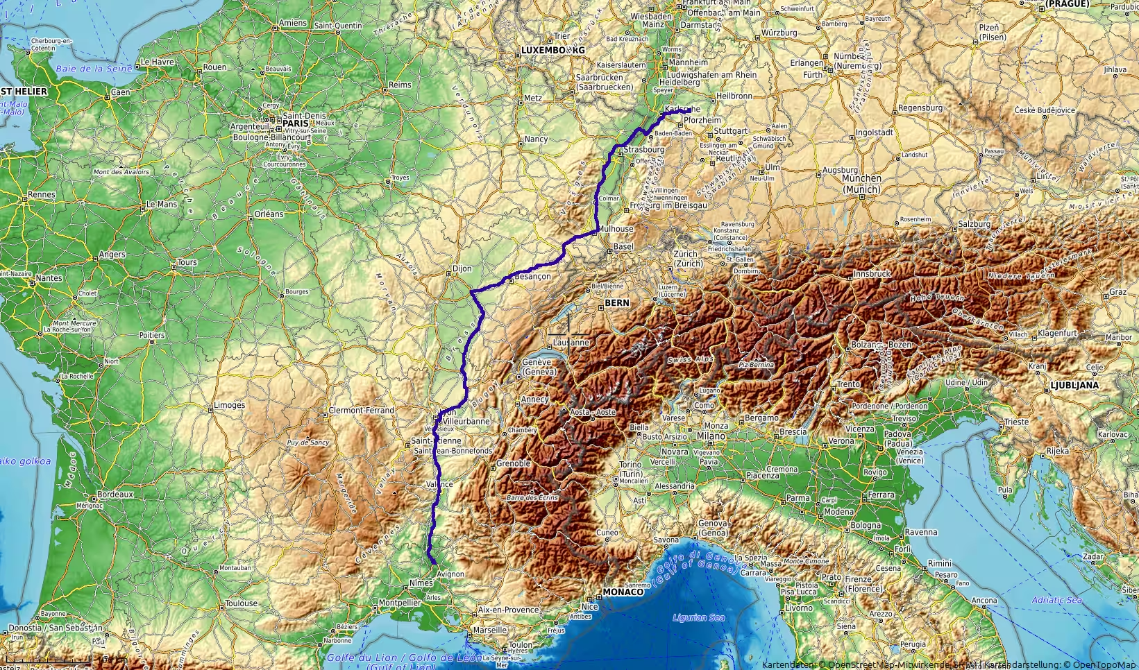
A long northbound road journey from Orange in southern France to the Enz region in southwestern Germany. The route follows the Rhône Valley past Valence and Lyon, crosses eastern France through the Besançon and Belfort corridors, continues north through Alsace past Mulhouse, Colmar and Strasbourg, then enters Germany near the Upper Rhine before reaching the Stuttgart / Vaihingen an der Enz region. With more than 800 kilometers of driving, this track marks the final long European return stage.
The journey began near Orange, in southern France, in the lower Rhône Valley. After the previous day’s long drive from eastern Spain into France, this track continued the northbound return across Europe. The route now left the Mediterranean south behind and followed a long inland corridor through eastern France, Alsace and southwestern Germany, ending in the Stuttgart / Enz region.
At the start, the landscape still belonged to the Rhône Valley. Orange lies in a region shaped by vineyards, river plains, Mediterranean light and the first clear signs of Provence. After the dry landscapes of Spain and the long Atlantic and desert routes of Morocco, this part of the journey felt more European in rhythm: motorways, service areas, agricultural land, towns and fast northbound connections.
The track began in the morning at a low elevation of around 49 meters. There was a short stationary period at the beginning, likely a final preparation before the long drive. Once the route began moving, it headed north through the Rhône corridor. This first section was broad and open, following one of France’s major north-south travel axes. The road ran between river landscapes, low hills, vineyards and larger transport infrastructure.
Leaving the Orange area, the route continued toward the Valence region. The Rhône Valley gave the first part of the day a clear direction. The road was fast and relatively linear, very different from the mountain roads of Morocco or the winding Anti-Atlas and Rif sections earlier in the trip. The journey was no longer about remote landscapes and difficult terrain. It was about covering distance through one of Europe’s main transit corridors.
A first longer stop occurred after roughly 109 kilometers, in the wider Valence / northern Rhône Valley area. This was a natural break after the first stage of the morning. The route had already left Provence behind and was moving toward the more central part of eastern France. The stop gave the day an early structure: departure from Orange, northbound drive through the Rhône Valley, then a pause before continuing toward Lyon.
After the break, the road continued north toward Vienne and Lyon. The landscape became more urbanized and infrastructural as the route approached the Lyon region. This area is one of France’s major road junctions, where traffic from the Mediterranean, the Alps, central France and northern Europe converges. The drive here felt less scenic in a traditional sense, but it had the character of a major European crossing.
Another short stop occurred south of Lyon. By this point, the route had covered almost 184 kilometers. The surroundings had changed from the quieter Rhône Valley south of Valence to a busier corridor influenced by the Lyon metropolitan area. Passing through or around Lyon marked one of the key transitions of the day. The route left the simple northbound Rhône axis and began turning northeast toward Burgundy, Franche-Comté and Alsace.
North of Lyon, the journey entered a different part of France. The Mediterranean influence began to fade. The road moved through the regions between Lyon, Bourg-en-Bresse, the Jura foothills and eastern France. The landscape became greener, more rolling and more varied. Fields, wooded areas, low hills and small towns replaced the stronger Mediterranean atmosphere of the morning.
This middle part of the route had a different travel rhythm. It was still mostly a motorway and long-distance road stage, but the scenery changed more subtly than in the Rhône Valley. The road ran across eastern French countryside, gradually moving away from the south and toward the German border regions. The sense of returning north became stronger with each hour.
Around midday, a longer stop took place after roughly 326 kilometers. This pause came in the wider Jura / Franche-Comté corridor, before the route continued toward Besançon and the Belfort-Montbéliard region. It was the main break of the middle day and divided the journey into two large chapters: the southern French section from Orange through the Rhône and Lyon corridor, and the eastern French section toward Alsace and Germany.
After this longer break, the road continued northeast. The route passed through a landscape of rolling hills, forests, open fields and regional towns. Compared with the vast desert roads in Morocco or the long coastal plains of the Atlantic Sahara, this part of France felt densely connected. The road was rarely isolated. There were frequent signs of settlement, transport infrastructure and cultivated land.
The route then approached the Besançon area, another important waypoint in eastern France. A stop occurred in this region after around 440 kilometers of travel. Besançon and its surroundings form part of the transition toward the Jura and the corridor leading to Belfort, Mulhouse and Alsace. The elevation rose gradually during this part of the drive, reaching some of the higher points of the day later in the afternoon.
East of Besançon, the road continued toward the Belfort and Montbéliard region. This section brought the route closer to the natural gateway between the Vosges and the Jura. The landscape became slightly more elevated and more structured by hills. The highest point of the day was recorded in this part of the route, at around 460 meters. Although this was not a dramatic mountain crossing, it was an important topographic moment: the road moved through the elevated transition zone before descending toward Alsace.
After crossing the Belfort / Montbéliard corridor, the route entered Alsace. This was another major change in the travel day. The landscape opened into the Rhine-side region of eastern France, with towns, fields, vineyards in the wider region, and the Vosges Mountains lying to the west. The road continued north along the Alsace corridor, passing the wider Mulhouse, Colmar and Strasbourg regions.
A pair of stops occurred in the Mulhouse / southern Alsace area. Together they formed a meaningful afternoon pause after more than 550 kilometers of travel. By this point, the route had crossed a large part of France from the Rhône Valley to the Rhine corridor. The journey had moved from Provence to eastern France, from Mediterranean lowlands to Alsace.
North of Mulhouse, the route followed the Alsace corridor toward Colmar and Strasbourg. This section had a distinct regional atmosphere. Unlike the wide, open Rhône Valley or the rolling landscapes near Besançon, Alsace has a more linear character between the Vosges and the Rhine. The road runs through a dense cultural and geographic corridor, with frequent towns, agricultural land, industrial zones and historic regions nearby.
The drive continued past the wider Colmar and Strasbourg areas. The landscape remained low to moderately elevated, and the road was fast. This part of the day was still a long-distance motorway stage, but it also marked the approach to Germany. The Rhine frontier was close, and the route was now moving toward the final international transition of the day.
A short stop occurred near the Strasbourg / northern Alsace area after just over 700 kilometers. This pause came before the route crossed into Germany. It was one of the last breaks before the final stage of the journey. By then, the route had already passed through Provence, the Rhône Valley, eastern France and Alsace.
After the Strasbourg region, the road crossed into Germany and continued through Baden-Württemberg. The landscape changed again, though more subtly than at earlier international crossings. The route entered the Rhine plain and then moved east and northeast toward Karlsruhe, Pforzheim and the Enz region. German motorway infrastructure, denser settlement and a different road rhythm shaped the final part of the day.
The first German section followed the Upper Rhine corridor. The road passed the wider Baden-Baden / Karlsruhe region, with the Black Forest rising to the east and the Rhine plain to the west. Compared with the long French sections earlier in the day, this part felt more compact and more densely populated. The destination was now relatively close, and the journey began to feel like the final return stage rather than another open road crossing.
A final short stop occurred near the Karlsruhe / Pforzheim corridor, after almost 786 kilometers of travel. This was the last practical pause before the final approach. The route then continued eastward into the more rolling landscapes of northern Baden-Württemberg. Elevation increased again toward the end of the track, reflecting the movement away from the Rhine plain and into the Enz / Stromberg region.
The final kilometers led toward the Vaihingen an der Enz area. The track ended in the early evening at around 310 meters above sea level. After starting the day in the Rhône Valley at less than 50 meters, the route finished in a higher, inland landscape of southwestern Germany. This gave the arrival a clear geographic contrast with the morning start.
In total, the route covered approximately 812 kilometers and lasted about ten hours and forty minutes from start to finish. The moving time was around eight hours and twenty-seven minutes, while stops and stationary periods accounted for a little over two hours. The average moving speed was high, reflecting the motorway character of most of the route.
What made this journey memorable was not a single dramatic landscape, but the long sequence of European regions. The route began in Provence and the lower Rhône Valley, passed Valence and Lyon, crossed eastern France toward Besançon and Belfort, followed Alsace north through the Mulhouse, Colmar and Strasbourg regions, entered Germany near the Upper Rhine, and finally reached Baden-Württemberg.
Seen in the context of the entire trip, this stage felt like the final European return after the Morocco crossing. The previous days had included the Atlantic Sahara, Dakhla, the Anti-Atlas, the Middle Atlas, Tangier Med, southern Spain and the French Mediterranean corridor. This track completed another major northbound step, moving from southern France to Germany in a single day.
The route was demanding because of its length, but relatively straightforward in character. It was mainly a long motorway drive, shaped by speed, distance and regular service-area stops. The landscapes changed gradually: Mediterranean south, Rhône corridor, eastern French hills, Alsace, Rhine plain and southwestern German uplands.
For a travel report, this day works as a closing transit stage. It lacks the raw remoteness of the Sahara roads or the mountain drama of southern Morocco, but it has the satisfaction of a long return journey. The road steadily carried the trip from the south of France back into Germany, crossing several cultural and geographic zones along the way.
By the end of the day, the journey had moved from Orange to the Enz region, from Provence to Baden-Württemberg, from the Rhône Valley to the German southwest. It was a long, practical and meaningful road stage: the kind of day that turns a distant overland journey into a completed return.