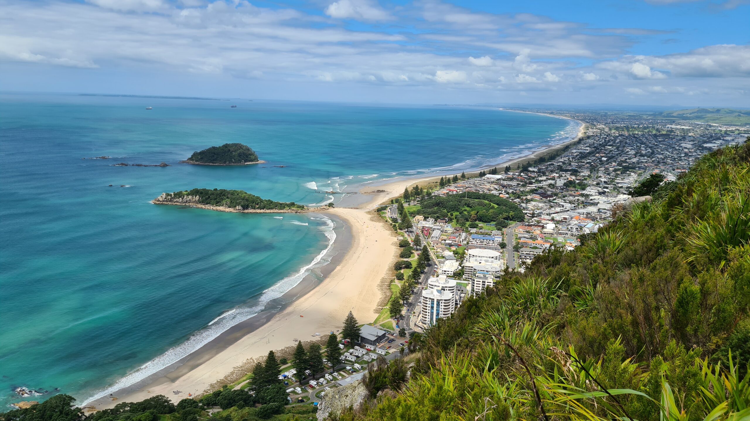


Mount Maunganui is a coastal town and popular seaside destination located in the Bay of Plenty region on New Zealand’s North Island. It forms part of the wider Tauranga metropolitan area and is situated on a narrow peninsula between the Pacific Ocean and Tauranga Harbour. The town is best known for its distinctive volcanic cone, Mauao, which rises prominently at the end of the peninsula.
Mount Maunganui combines a relaxed beach-town atmosphere with modern urban amenities. The area includes residential neighborhoods, tourist facilities, recreational spaces, and commercial zones, all closely integrated with the surrounding natural environment. Its long sandy beaches, mild climate, and outdoor lifestyle make it one of New Zealand’s most desirable coastal communities.
The climate is temperate and maritime, with warm summers, mild winters, and high levels of sunshine. The local economy is driven by tourism, hospitality, retail, education, and services, with close economic links to the Port of Tauranga, one of the largest ports in the country.
History
The Mount Maunganui area has a long history of Māori settlement. The volcanic cone, known as Mauao, holds deep cultural and spiritual significance for local Māori iwi, including Ngāi Te Rangi and Ngāti Ranginui. Mauao is considered a sacred landmark and plays an important role in local traditions and oral histories.
European settlement in the area began in the 19th century, initially focused on farming, fishing, and port-related activities. The development of Tauranga Harbour and improved transport links gradually transformed Mount Maunganui into a seaside resort and residential area.
Throughout the 20th century, Mount Maunganui grew in popularity as a holiday destination, particularly among domestic tourists. In recent decades, population growth and urban development have increased, while efforts have been made to preserve public access to beaches and natural spaces.
Geology
Mount Maunganui’s defining geological feature is Mauao, an extinct volcanic cone formed approximately 2 to 3 million years ago. Mauao is composed mainly of andesite and basalt and represents the eroded remnant of a larger volcanic structure.
The peninsula itself consists of sand dunes and coastal deposits formed by wave action, wind, and sediment movement over thousands of years. These processes created the long sandy beaches and dune systems that characterize the area.
The surrounding Tauranga Harbour is a drowned river valley shaped by rising sea levels following the last ice age. Ongoing coastal and marine processes continue to influence shoreline stability and land use planning in the region.
Things to See
Mount Maunganui offers a wide range of natural, recreational, and cultural attractions:
Natural and Coastal Attractions
- Mauao summit walk, offering panoramic views of the Bay of Plenty
- Main Beach, known for surfing, swimming, and coastal walks
- Pilot Bay, a calm harbor-side beach ideal for water sports
- Coastal and dune ecosystems along the peninsula
Recreation and Lifestyle
- Walking, jogging, and cycling paths around the mountain and coastline
- Surfing, paddleboarding, and kayaking
- Hot saltwater pools at the base of Mauao
- Parks, picnic areas, and outdoor fitness spaces
Local Life and Events
- Cafés, restaurants, and local markets
- Community events and seasonal festivals
- Easy access to Tauranga city center and surrounding attractions
- Strong outdoor and wellness-focused lifestyle culture