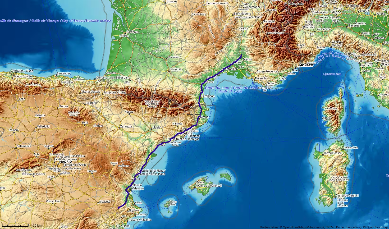
A long northbound road journey from the Valencian interior to Orange in southern France. The route descends toward the Spanish Mediterranean corridor, passes Valencia, Castellón, Tarragona, Barcelona and Girona, crosses the France-Spain border near the eastern Pyrenees, and continues through Perpignan, Narbonne, Montpellier and the lower Rhône region. With almost 900 kilometers of driving, this track marks the transition from Spain into France and the beginning of the final European return.
The journey began in the Valencian interior, in the hill country west of the Mediterranean coast. After the previous day’s long drive from Algeciras across southern and eastern Spain, this stage continued the northbound return through Europe. The route now left the dry landscapes of southeastern Spain behind and followed a long corridor along the Spanish Mediterranean side before crossing into France and ending near Orange, in the lower Rhône Valley.
At the start, the track was still inland, at almost 500 meters above sea level. The surroundings belonged to the southern Valencian interior rather than the immediate coast: hills, valleys, cultivated land, towns and dry Mediterranean uplands. It was a very different setting from the ferry-port atmosphere of Algeciras or the wide semi-arid landscapes of Murcia and eastern Andalusia. The road began in a quieter inland environment before gradually descending toward the main coastal motorway corridor.
The first minutes of the track showed a brief stationary period, almost like a final preparation before the day’s long drive began. After that, the route moved northeast, leaving the inland hills behind and gradually approaching the wider Valencia region. The road descended quickly from the higher starting area toward lower ground, and the landscape opened into the broader Mediterranean corridor of eastern Spain.
This first section had a transitional character. The previous day had ended inland, away from the coast, but the new route quickly reconnected with the main northbound axis of Spain’s Mediterranean side. The scenery changed from hill country to a more urbanized and infrastructural landscape. Roads became faster, settlement became denser, and the route began to feel like a long-distance European motorway stage rather than a remote overland crossing.
The first major orientation point was the Valencia region. The track passed the wider metropolitan area in the morning, after roughly 100 to 125 kilometers. The elevation had already dropped dramatically by then, from almost 500 meters at the start to near sea level. This descent shaped the early part of the day. It marked the movement from inland Spain back to the coastal plain.
A short stop occurred in the Valencia area. It was not long, but it came at a natural moment in the route: after the descent from the inland hills and before the long continuation north along the Spanish Mediterranean corridor. The landscape here was clearly more populated than the regions crossed in Morocco or the dry interior of southern Spain. Urban edges, traffic, fields, industrial areas and motorway infrastructure all became part of the journey.
After Valencia, the route continued north along the eastern side of Spain. The Mediterranean itself was not always visible, but its influence was constant. The road ran through a long corridor between coastal plains, cities, agricultural land and low mountain ranges. Compared with the mountainous Moroccan stages or the high roads of Andalusia, this was a faster and more linear travel day. The road was built for distance.
The next stage led toward Castellón and the northern Valencian coast. This part of the journey remained relatively low, with only gentle elevation changes. The road passed through a region shaped by citrus agriculture, coastal towns, industrial areas and inland hills set back from the sea. The journey had a steady rhythm: long driving sections, short pauses, and continuous northward progress.
Around the Castellón and northern Valencian section, the route was already well established on the Mediterranean axis. The day no longer felt like a local Spanish drive. It had become a continental transit stage, a route that would continue beyond Spain and into France before evening. The sense of direction was clear: north, toward Catalonia, the Pyrenees corridor and the Rhône Valley.
A second short stop appeared farther north, around the 200-kilometer mark. This pause came in the coastal corridor between the Valencian region and southern Catalonia. By this point, the route had already left the starting area far behind and was approaching the Ebro Delta region. The landscape here is one of Spain’s major transitions along the Mediterranean: from the Valencian coast into Catalonia, with mountains and plains alternating near the sea.
The route then entered Catalonia. The road passed through the broader Tarragona region, one of the key stages of the day. A longer stop occurred around Tarragona at midday, and the track shows this as one of the more substantial breaks of the journey. It came after more than 370 kilometers from the start and divided the route into two major parts: the Spanish Mediterranean drive from the Valencian interior to Tarragona, and the continuation through northern Catalonia and into France.
The Tarragona region gave the journey a different atmosphere. It is more northern than Valencia, more closely connected with Catalonia, and positioned between the Mediterranean coast and inland hills. After the long morning drive, stopping here created a strong midpoint in the day. The route had already covered a major distance, but the French border and the final destination were still far ahead.
After Tarragona, the road continued northeast toward the Barcelona region. This section was one of the busiest and most infrastructural parts of the day. The route passed through or around the large metropolitan corridor of northeastern Spain, where traffic, motorways, industrial zones, suburbs and coastal development create a very different travel environment from the open roads farther south.
The approach toward Barcelona changed the rhythm of the journey. The road still moved quickly, but the landscape became denser and more complex. Instead of long open plains or empty desert roads, the route now passed through one of the most developed corridors on the Iberian Peninsula. The Mediterranean motorway here is a major European transport axis, and the track reflected that character.
A stop occurred north of the Barcelona area, around the 490-kilometer mark. This was another practical break after a demanding section through dense traffic corridors. The elevation was slightly higher here, suggesting that the route had moved inland from the immediate coast toward the hills north of the city, likely in the direction of the Vallès and Girona corridor. The journey was now leaving the Barcelona metropolitan area behind and entering the road toward the Pyrenees border.
North of Barcelona, the route continued toward Girona. The landscape opened again after the dense metropolitan section. The road passed through a corridor of towns, wooded hills, agricultural areas and lower mountain landscapes. This section felt like a gradual preparation for crossing from Spain into France. The Pyrenees were not a high mountain crossing here in the dramatic sense, but the route still moved through the northeastern gateway of the Iberian Peninsula.
A short stop appeared around the Girona region, after more than 560 kilometers of travel. It came at a useful moment before the final Spanish section and the border crossing. By then, the journey had already passed through the Valencian region, northern Valencia, southern Catalonia, Tarragona, Barcelona and Girona. The day had become a true long-distance passage along Spain’s Mediterranean side.
The road then approached the France-Spain border near La Jonquera and Le Perthus. This was one of the key geographic moments of the day. The route left the Iberian Peninsula and crossed into southern France. Compared with the ferry crossing between Morocco and Spain, this border transition was less dramatic in practical terms, but it still marked a major shift in the journey. The road, signs, language, traffic patterns and landscape all changed subtly.
The track showed another short stop near the border region. This fits well with the character of the route. Border areas often create natural pauses, whether for fuel, rest, traffic, or simply as a marker between countries. After crossing the border, the journey entered the French side of the Mediterranean corridor.
The first French section led through the Roussillon region, around Perpignan and the plains below the eastern Pyrenees. The landscape here is Mediterranean but distinct from Spain. The road runs between mountains, vineyards, towns, dry plains and the wider coastal lowlands of southern France. After many hours in Spain, the shift into France gave the day a new chapter.
From the Perpignan area, the route continued north toward Narbonne. This part of southern France has a strong Mediterranean road character: dry hills, lagoons and coastal plains nearby, vineyards, old towns, motorway infrastructure and the sense of moving along the historic corridor between Iberia and the Rhône Valley. The road remained fast and direct, but the scenery had changed.
A stop occurred in the Narbonne region after roughly 710 kilometers from the start. This pause came late in the afternoon, after the route had already crossed the border and entered southern France. It marked the beginning of the final major section of the day: the long run through Languedoc toward the lower Rhône.
After Narbonne, the road continued east and northeast through Languedoc. The route passed the wider Béziers and Montpellier corridor, one of the main transport axes of southern France. The Mediterranean was still not far away, but the road also began to feel increasingly connected with the Rhône Valley. The landscape included dry plains, vineyards, hills and developed motorway surroundings.
The approach toward Nîmes and the lower Rhône region formed the final transformation of the day. The route moved away from the Spanish Mediterranean corridor and into southeastern France. The scenery became more Rhône-like: flatter in places, with vineyards, river plains, historic towns and the first clear sense of Provence nearby.
Another stop appeared near the Nîmes / lower Rhône corridor, after more than 800 kilometers of travel. This was the last substantial pause before the destination area. By this point, the route had become a very long European transit stage. The journey had crossed eastern Spain and southern France in one day, moving from the Valencian interior to the edge of Provence.
The final kilometers led toward Orange. The track ended near the town in the early evening, close to the Rhône Valley and not far from Avignon. Orange gave the day a clear northern endpoint. It is a place associated with southern France, Roman history, vineyards and the transition toward Provence and the Rhône corridor. After starting the day in the Valencian interior, arriving near Orange felt like a major geographic shift.
The route ended at low elevation, around 50 meters above sea level. This was much lower than the starting point and reflected the broad descent from inland Spain to the Mediterranean and Rhône corridors. The highest point of the day was at the very beginning, close to 500 meters, while the route spent much of the day at low elevations near coastal plains and river corridors.
In total, the track covered approximately 899 kilometers. The recorded duration was a little over eleven hours, with almost nine hours of moving time and more than two hours of stops. The average moving speed was high, reflecting the motorway character of much of the route. Unlike many Moroccan stages, this was not a winding mountain or desert-road day. It was a long, fast, cross-border European drive.
What made the journey memorable was its scale and continuity. The day began in the Valencian interior, descended to the Spanish Mediterranean corridor, passed Valencia, Castellón, Tarragona, Barcelona and Girona, crossed into France, continued through Perpignan, Narbonne, Montpellier and the lower Rhône region, and ended near Orange. It was a route through regions rather than isolated places.
The strongest feature of the day was the northward progression. The landscape changed from dry Spanish inland hills to coastal plains, from the busy Catalan motorway corridor to the French Mediterranean region, and finally to the edge of Provence. The journey did not have the raw remoteness of the Sahara road or the mountain drama of the Anti-Atlas, but it showed another kind of travel: the long continental movement through connected European landscapes.
In the context of the wider trip, this track marked the clear return north. After the Morocco crossing, the Atlantic Sahara stages, the Anti-Atlas, the Middle Atlas, the ferry return and the long drive through southern Spain, this day carried the route deep into France. It felt like the overland journey was now shifting from expedition mode into the long European return.
For travelers, this route is demanding mainly because of distance and duration. The roads are generally fast, but almost 900 kilometers make it a serious driving day. The stop pattern shows the importance of regular breaks: Valencia, the Tarragona region, north of Barcelona, Girona, the border area, Narbonne and the lower Rhône corridor all helped structure the long route.
The memory of the day is one of forward movement. There were no extended scenic detours, but there was a strong sense of passage: Spain giving way to France, Catalonia giving way to Languedoc, and the Mediterranean corridor leading toward the Rhône Valley. By the time the route ended near Orange, the journey had crossed a large part of western Europe’s southern arc.
This was a travel day defined by distance, speed and transition: from the Valencian interior to southern France, from Spain to France, from the Iberian Peninsula to the lower Rhône, and from the Mediterranean coast road toward Provence.